


As Typhoon Tisoy with the international name of Kammuri made its way across the country carrying heavy rains and fierce winds, Filipinos shared how the latest tropical cyclone wreaked havoc in its path.
Twitter user Connie Ona shared a video of winds blowing the trees in a residential area in Calamba, Laguna, particularly Southwynd Residences. It was taken at 12:08 p.m.
#TyphoonTisoy #Continous heavy rains. Keepsafe filipinos#Signal2@Laguna🌨️☔ pic.twitter.com/JEpPJMKOI1
— Connie (@junjun120672) December 3, 2019
In an online interview with Interaksyon, Ona admitted that she had a hard time taking a video since the winds were so strong outside their house.
Laguna was placed under tropical cycle wind signal number three at 11:00 a.m. which winds of 121 to 170 kph were recorded.
Kate Ongjuco, another Twitter user, shared a video of trees being assaulted by the strong wind in a residential area of Mamburao, Occidental Mindoro. It was taken around 3 p.m.
Fallen leaves and several branches were also seen scattered on the street.
As of 3 pm here in Mamburao, Occidental Mindoro. #TyphoonTisoy @YouScoop @cnnphilippines @GMA_PA @gmanewsbreaking @gmanetwork @24OrasGMA @PhilippineStar pic.twitter.com/azePJXar0D
— Kate Ongjuco (@imKATElingz) December 3, 2019
Another Twitter user, Eroll Santos, also shared pictures and a video taken by his friends in Caminawit, San Jose at Occidental Mindoro at 11 a.m.
A picture taken by Nik Delos Reyes showed a fallen cell tower that damaged parts of their residence, particularly their gate.
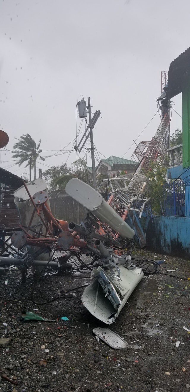
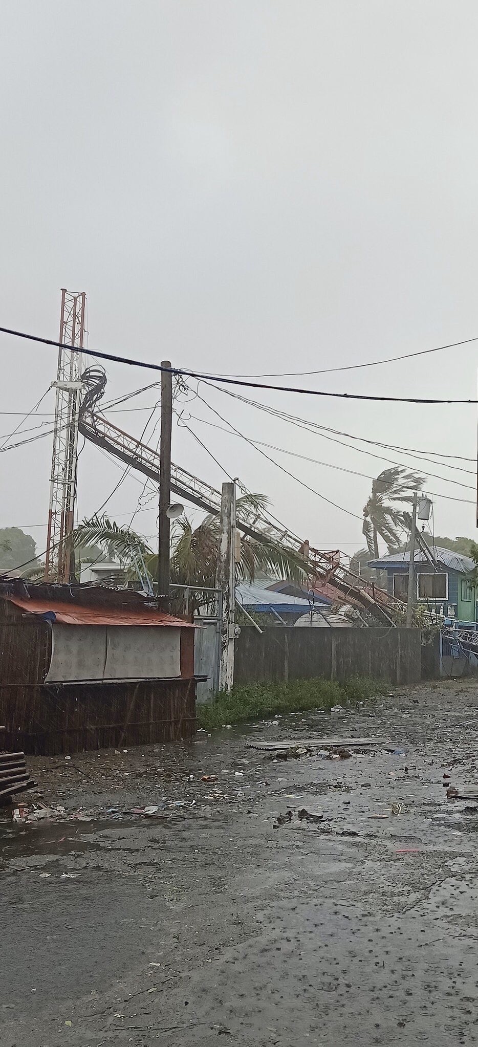
A view of the fallen cell tower from afar. (Photo by Nik Delos Reyes via Eroll Santos)
Another of Santos’ friends, Kimberly Garzon, also sent a video of the damage from another perspective.
video was sent to me by my bestfriend. that’s our fucking gate!! 😭#TisoyPH #TyphoonTisoy #Tisoy pic.twitter.com/FswsU6q1IT
— Eroll (@pepperoll_) December 3, 2019
Occidental Mindoro including Lubang Island was placed under Tropical Cyclone Wind Signal No. 3 at 11:00 a.m.
Fierce winds also slammed on the coastal areas of Mabini, Batangas, particularly Sitio Centro in Barangay Gasang.
Twitter user Eugene Asilo shared a video of the waves crashing on the shores as trees swayed in the background at around 3 p.m.
Height of waves continue to grow as the wind blows harder in the coastal areas of Mabini, Batangas. Keep us all safe God!🙏🏻 #TisoyPH #TyphoonTisoy pic.twitter.com/FffVHvMBgr
— Eugene Asilo (@eugeasilo) December 3, 2019
Batangas was placed under tropical cycle wind signal number three at 11:00 a.m.
Metro Manila was not spared from the onslaught of the typhoon as well.
Twitter user Red Dapula shared a video he took while traversing on the southbound bridge of Boni Avenue, Mandaluyong at around 3:15 p.m.
“Pati phone ko lilipadin. Ingat tayong lahat!” he wrote.
Pati phone ko lilipadin. Ingat tayong lahat! #TyphoonTisoy #Tisoy pic.twitter.com/zJlxYes04D
— 卂ㄩᎶㄩ丂ㄒ (@redishhhhh) December 3, 2019
Typhoon Tisoy entered the Philippine Area of Responsibility on Saturday, November 30, the opening day of the SEA Games.
Even before it made landfall, classes and work suspensions have already been in effect in some parts of the country. It packed winds of 150 kph and gusts of up to 185 kph at that time.
According to state weather bureau PAGASA, the typhoon has now weakened and is already off the coast of Occidental Mindoro based on its weather bulletin issued at 5:00 p.m.
Quezon and Rizal will continue to experience frequent to continuous heavy rains.
Meanwhile, Mindoro Provinces, Metro Manila, Central Luzon, the rest of CALABARZON, Cagayan Valley, Cordillera Administrative Region, Marinduque, and Romblon will encounter occasional to frequent heavy rains.
Calamian Islands will experience intermittent heavy rains.
Typhoon Tisoy is forecasted to be outside the Philippine Area of Responsibility by Thursday afternoon.


