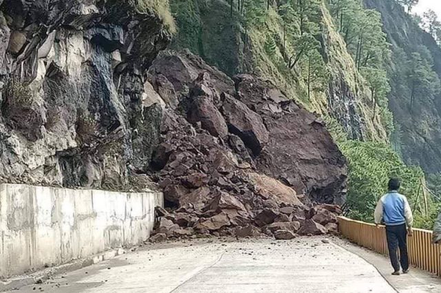
Is it Kennon Road in a photo showing a landslide following the 7.0-magnitude earthquake in Northern Luzon?
The photo circulated on social media following the earthquake that struck Abra and rattled areas across Luzon, descriptions of which claim that it was on Kennon, also called Rosario-Baguio Road, where the landslide was photographed.
The page of the Mountain Province‘s Disaster Risk Reduction and Management Council, however, indicated that the landslide occurred on Halsema Highway, or the Benguet-Mountain Province Road.
“To all motorists, please be advised that some roads along Halsema Highway are closed due to landslide. We encourage that all travels be postponed, aftershocks are also expected. Keep safe!” it said, attaching contributed photos to the post.
Residents also confirmed that the photograph was taken on Halsema Highway, and not on Kennnon.
Among the ones that went viral was a picture of fallen debris that completely blocked motorists’ access.
Claims
“This picture is Kennon Road Camp 3,” a Facebook user wrote.
“Kennon Road was damaged as a 7.3 magnitude earthquake hit Lagangilang, Abra, on 27 July,” a news outlet wrote in a post.
A radio station also shared the same picture with a similar claim.
“Look: Epekto ng malakas na lindol na naramdaman sa bahagi Kennon Road,” it claimed.
“Please check your sources! This is in Monamon, Bauko Mt. Province. It’s Mt. Data Cliff, FYI,” a Baguio City resident wrote in the comments.
“Ay sus… Bauko, Mt. Province ‘yan…” another Facebook user commented.
“Halsema Highway Mountain Province po ‘yan,” shared a different social media user.
Kennon Road, meanwhile, has been closed off to motorists on July 27 after the powerful 7.0 quake, whose epicenter was detected in Abra.
These roads to and from Baguio are also closed to motorists after #AbraQuake.
🔴 More updates: https://t.co/RnynbUJZEh pic.twitter.com/a52YWFuXut
— Philstar.com (@PhilstarNews) July 27, 2022
Where it is
Halsema Highway is situated within the Cordillera Central Range and stretches from Baguio’s city limit to Bontoc’s municipality. It has a length of around 150 kilometers.
The national secondary highway traverses eight municipalities of the Benguet province and four Mountain Province towns, including Bauko.
Meanwhile, Kennon Road is a roadway connecting Baguio City to Rosario in La Union. It is 33.7 kilometers in length.
While it is not the area where the viral picture was taken, the road is closed to all motorists as of 10 a.m., according to the public information office of Baguio City.
—
This story is part of the Philippine Fact-check Incubator, an Internews initiative to build the fact-checking capacity of news organizations in the Philippines and encourage participation in global fact-checking efforts.
Interaksyon is part of #FactsFirstPH, a multi-sectoral initiative promoting truth in public space and demanding accountability for falsehoods. For those interested to join the initiative, email [email protected]
Interaksyon is also a founding partner of Tsek.ph, a collaborative fact-checking project for the 2022 Philippine elections. It is an initiative of academe, civil society groups and media to counter disinformation and provide the public with verified information.


