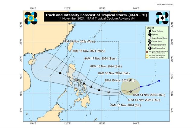
The University of the Philippines Resilience Institute advised Metro Manila residents to prepare for the potential effects of the incoming Tropical Cyclone Man-yi, which will be domestically called “Pepito,” this weekend.
The hub on Thursday, November 14, reshared a bulletin released by state weather PAGASA at 11 a.m. about the forecast track and intensity of “Man-yi” which is expected to enter the Philippine area of responsibility (PAR) by Thursday evening.
Once it enters the PAR region, it will referred to by its local name, “Pepito.”
Based on PAGASA’s bulletin, the tropical cyclone will intensify as a typhoon early Friday, November 15, before approaching the country’s landmass.
ABS-CBN resident meteorologist Ariel Rojas said that it might “continuously intensify while crossing the Philippine Sea and may reach super typhoon strength.”
He added that “Man-yi” might make a “very close approach to or landfall over Samar or Bicol” by Saturday, November 16 as a typhoon.
It will remain in that category as it traverses CALABARZON and “very close” to Metro Manila by Sunday, November 17.
The tropical cyclone will then exit the Philippine landmass by Monday, November 18.
Rojas cautioned Luzon and Visayas residents to “prepare for the impacts of the potential super typhoon’s very destructive winds, torrential rains, and storm surge during its passage.”
However, he emphasized that “Man-yi’s” track might change as it will be affected by the “strengthening or weakening” of the high-pressure area located south of Japan.
A high-pressure area is associated with calm conditions and sunny skies.
Meanwhile, the UP Resilience Institute cautioned people in the National Capital Region to make the necessary preparations before “Man-yi’s” expected passage near the area.
“Magkakaiba pa ang track na predicted para sa bagyong tatawagin nating #Pepito,” it said in a Facebook post.
“Pero sa iba’t ibang tracks na ito, hagip ang Metro Manila kaya maghanda na po tayong lahat para sa bagyo sa weekend. Ingat po tayong lahat,” the institute added.
Typhoon and weather enthusiasts also cautioned Metro Manila residents about “Man-yi’s” potential passage near the area.
Typhoon enthusiast Matthew Cuyugan said that the tropical cyclone might start affecting the capital region, Southern Luzon, and Central Luzon by Saturday with its “heavy rains.”
It will continue until Sunday.
He also said there is a possibility of “Man-yi” becoming a super typhoon “due to a very favorable environment in the Philippine Sea.”
“Regardless in the area of landfall, EVERYONE is encouraged to prepare, be alert and continuous monitoring,” Cuyugan said.
Like Rojas, he also emphasized that the forecast “remains subject to change,” especially since the disturbance is not yet within the PAR region.
Tropical Storm #ManYi is expected to enter the Philippine Area of Responsibility (PAR) this evening as a SEVERE TROPICAL STORM, and be named #PepitoPH by PAGASA.
It may reach TYPHOON intensity within 24 hours. Reaching super typhoon category is not ruled out due to a very… pic.twitter.com/pu9YximyLq
— Matthew Cuyugan (@mscuyugan) November 14, 2024
Cuyugan also stressed that Metro Manila is expected to experience “heavy to intense” rains of 100-200 millimeters on Saturday, November 16 due to “Man-yi.”
To METRO MANILA:
Possible HEAVY to INTENSE rains (100-200 mm) on Saturday, November 16, 2024 due to Tropical Storm #ManYi that will enter PAR later today (#PepitoPH).
Precautionary measures are advised! ⚠️
📷: DOST-PAGASA https://t.co/r3KDh3q0NI pic.twitter.com/cxo3DH1Dr8
— Matthew Cuyugan (@mscuyugan) November 14, 2024
Based on PAGASA’s rainfall outlook as of 2 p.m., Metro Manila will experience “heavy to intense” rains from Saturday afternoon to Sunday afternoon due to “Man-yi’s” passage.
“Numerous flooding events are likely, especially in areas that are urbanized, low lying or near rivers,” the weather bureau said.
Landslides are also likely in moderate to highly susceptible areas.
The next bulletin about “Man-yi” will be released by PAGASA at 11 p.m.
Meanwhile, Typhoon Ofel (international name: Usagi) is currently battering parts of Northern Luzon in its passage.
According to its 2 p.m. bulletin, the Babuyan Islands and some portions of mainland Cagayan were experiencing up to typhoon-force winds.
Other provinces including Batanes, Apayao, Ilocos Norte, Isabela, Kalinga, Abra, Mountain Province, Ifugao, Quirino, Nueva Vizcaya, Benguet, Ilocos Sur, La Union, and Aurora are also experiencing “Ofel’s” wrath.
“Ofel” is expected to weaken until it becomes a remnant low by Monday, November 18.
Ana Liza Solis, PAGASA’s Chief of Climatology Monitoring and Prediction Section, explained that the country is experiencing La Niña-like conditions, with cooler sea surface temperatures in the Eastern Pacific Ocean compared to the warmer temperatures in the western section.
Warmer sea surface temperatures make it favorable for water evaporation and cloud formation, which can result in tropical depressions and storms or even typhoons.
La Niña is usually associated with above-normal rainfall conditions across most areas of the country.


