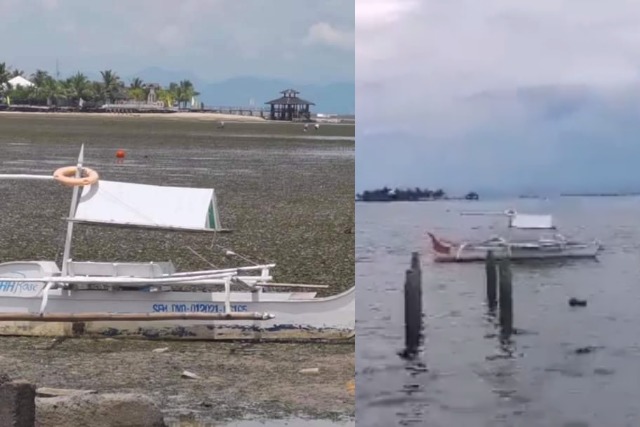
An online science community allayed the fears of the public and explained that low tide might have caused the sudden drying up of an islet in Davao del Sur.
Photos of the nearly parched Passig islet located in Barangay Bato, Sta. Cruz, Davao del Sur previously alarmed social media users who warned others of potential tsunami or upcoming disaster.
“Be alert lng po mag residents, parang may nabasa ako dati pag ganyan parang bwelo ganon, tsaka kung hindi naman normal na yang na nangyayari [diyan],” a Facebook user claimed.
“Mag-ingat po kayo lagi diyan sa tabi ng dagat baka po malaking tsunami na po ‘yan sa sunod, ‘wag naman po sana mangyari,” another online user commented.
A science page called the Philippine Weather System/Pacific Storm Update shared photos of the islet on Tuesday, May 25. The photos were from Facebook user Mark Anthony Pinote, a resident of the Davao del Sur.
“Natuyo ang karagatan sa bahagi ng Passig Islet sa Barangay Bato, Sta. Cruz, Davao del Sur, base sa kuha ng isang residente roon,” read the caption.
In the photos, nearly all the water surrounding the islet seemed to have evaporated and only the wet sand and other natural debris which used to be underwater remained.
One of the photos also showed a small boat sitting on what’s left of the water.
The post earned more than 1,900 shares, 644 comments and over 5,500 reactions, wherein 1,800 are sad reactions.
Hours later after these photos blew up, provincial radio station 91.5 Brigada News FM-Radio released an update where the islet was surrounded with natural water again.
Some social media users later expressed theories that what happened is a common phenomenon in bodies of water called “low tide.”
“Low tide lang po ‘yan, ‘di na bago sa malawak na area ng Passig islet at Secret island diyan sa Sta. Cruz Davao del Sur,” one user said.
Science community page called The Watchmen’s Earth and Space connection provided a more detailed explanation on how tides work, citing the influence of the moon’s gravitational pull.
“The two tidal bulges caused by inertia and gravity will rotate around the Earth as the moons position changes. These bulges represent high tides while the flat sides indicate low tides,” the post read.
“Centrifugal Force is the force created by the Earth and moon (or any two objects) whirling around this central point. The force is always outward; away from the bodies whose gravitational attraction is causing it,” it added.
The science community then said there’s nothing to fear about the drying up of the islet.
“So no [need] to panic as we all know ocean usually experience high tide and low tide,” it said.
An article from the National Geographic defined the tide as the “alternating advance and retreat of seawater along a coastline.”
“High tide is when water advances to its furthest extent onto the shoreline. Low tide is when it recedes to its furthest extent. Some freshwater rivers and lakes can have tides, too,” the article said.
Many factors affect the frequency of a shoreline’s tide such as physical features and depth of water.
“Most shorelines experience two high and two low tides within a twenty-four-hour period, though some areas have just one of each. A coastline’s physical features, such as a wide sandy beach or a rocky cove, along with the depth of the water just offshore, affect the height of the tides,” the National Geographic said.

