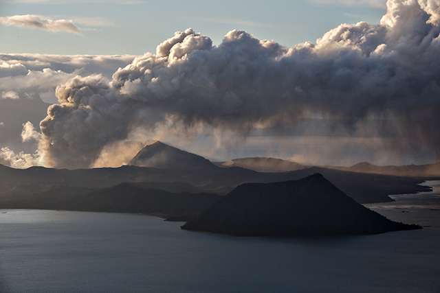
Clarifications were made after pictures of Taal Volcano Island supposedly surrounded by large amounts of ash and smoke made the rounds on social media when its alert level was raised on Tuesday.
Mark Timbal, spokesperson of the Office of Civil Defense, said that the images were shot last year and that it doesn’t reflect the current state of the Batangas-based volcano.
“Taal is at Alert Level 2, yes, pero wala pong katotohanan ‘yung kumakalat na photos na matindi ang pagbuga ng usok at abo. The thumbnail from a post circulating in socmed (social media) was a shot taken in 2020,” he said in a message to reporters.
State volcanologists on Tuesday raised the alert level of Taal Volcano from Alert Level 1 or “low level of unrest,” to Alert Level 2 or of “increasing unrest” almost a year since it was downgraded to Alert Level 1.
The Philippine Institute of Volcanology and Seismology said that the volcano has been “exhibiting increased unrest” since February 13, citing shallow volcanic episodes and low-frequency volcanic earthquakes.
It added that there was an increase of temperature and acidity in Taal Volcano’s Main Crater lake, as well as an ongoing slight ground deformation of the Taal Volcano Island.
“This means that there is probable magmatic activity that may or may not lead to an eruption,” Phivolcs said.
The agency is not yet recommending an evacuation but reminded the public that the Taal Volcano Island is still a “permanent danger zone.”
Entering it, as well as going to the vicinities of the Main Crater Lake and the Daang Kastila fissure, is still strictly prohibited.
Timbal, also the officer-in-charge of the OCD’s Public Affairs office, told Interaksyon that their office was alerted some social media users shared photos and thumbnails of the volcano island’s state last year and connected it with the increase of its alert level this year.
Taal Volcano last erupted on Jan. 12, 2020 after years of slumber and left more than 30 people dead. Thousands of Filipinos were also displaced from their homes.
Neighboring regions, including Metro Manila, were also affected by its ashfall that prompted them to wear N95 face masks for a while.
Latest photos of Taal Volcano Island
Timbal then shared the current photo of the Taal Volcano Island to counter the outdated photos.

