In its SEVERE WEATHER BULLETIN #34, posted late Sunday afternoon, the state weather bureau Philippine Atmospheric, Geophysical and Astronomical Services Administration (PAGASA) indicated that Tropical Depression #UrdujaPH slightly changed trajectory to move west-southwest heading toward the upper reaches of Palawan island, to include possibly the Calamian Island group.
Tropical Cyclone Warning Signal No. 1 was hoisted over all of Palawan, Aklan and Northern Antique.
“Scattered to widespread rains will continue over southern part of Mindoro Provinces, Marinduque, Romblon, Palawan, Aklan, Capiz and Antique,” the weather adviory said.
Meanwhile, at 2:00 PM today, the Tropical Depression outside the PAR was estimated based on all available data at 1,950 km East of Mindanao (4.8°N, 143.6°E) with maximum sustained winds of 40 km/h near the center and gustiness of up to 50 km/h.
A partial report compiled by the National Disaster Risk Reduction Management Council indicated at least 2,039 passengers stranded by suspended port operations at the storm-affected harbors of Marinduque, the Mindoro provinces, Romblon and Palawan.
At least 71 families were being assisted at temporary evacuation centers, comprising some 320 individuals.
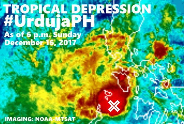
At 4:00 p.m., the center of Tropical Depression “URDUJA” was estimated based on all available data at 65 km South of Romblon, Romblon (12.0 °N, 122.3 °E), although a false-color rendering of the satellite fix by the US-based NOAA-MTSAT service at 6 p.m. showed the storm at sea having passed Panay Island and headed about halfway toward northen Palawan.
The storm was clocked having maximum sustained winds of 55 kph near the center and gusts of up to 80 kph, and moving west-southwest at 15 kph
At 2 p.m. Monday, December 18th, the weather disturbance, which could pick up more precipitation at sea, is forecast to be at the vicinity of Taytay, Palawan (10.8°N, 119.5°E).
Curiously, the 8 p.m. weather advisory of PAGASA stated:
SEVERE WEATHER BULLETIN #35
FOR:Tropical Depression Urduja
Tropical Cyclone: WARNING
ISSUED AT:8:00 PM, 17 December 2017
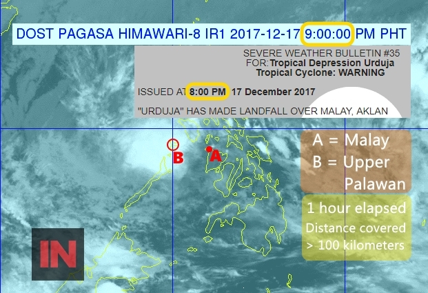
“URDUJA” HAS MADE LANDFALL OVER MALAY, AKLAN
But the Infra-Red map of the Himawari satellite fix posted also by PAGASA showed that, over an elapsed time of about one hour, at 9 p.m., the storm that was supposed to cover only about 15 kilometers an hour seemed to have jumped more than 100 kilometers. See image reproduced above, where Point A represents the approximate location of Malay where the storm was supposed to have made landfall at 8 p.m., and Point B the satellite fix of the storm’s cloud area over the northern reaches of Palawan at 9 p.m., somewhere near the Calamian Group.


